Tuesday 14 February 2012

On to Appomattox Court House

On April 3rd, 1865 less than  a week before his surrender Lee and The Army of North Virginia left Richmond and Petersburg. His objective was to move south and join up with remnants of General Joe Johnson's Army of Tennessee then fighting to North Carolina.  However with Grant blocking him to the south and east, Lee could only move west.  The battle map below shows the movement of Lee's  columns towards Appomattox Court House.

Th Retreat to Appomattox Court House
Lee was harassed by Grant along the entire route in a series of skirmishes. The most serious of which was at Sailor's (or Saylor's) Creek on Apr 6th where the Confederate Army really became unraveled.losing approximately 7700 soldiers and 8 generals captured including Lee's own son.  Lee's army staggered on in the hope of reaching Appomattox Station (Now the town of Appomattox and not to be confused with the village Appomattox Court House) hoping to reach supplies that were waiting for him. Unbeknownst to Lee was the fact that Union cavalry troops under General Custer had already arrived at Appomattox Station and had destroyed the supplies (Apr 8th). At the same time Grant sent a note to Lee offering him generous terms of surrender.  On the morning of April 9th, Lee tried one more push with his cavalry to reach Appomattox Station but as his troops crested a rise just south of Appomattox Court House they were confronted by the entire Union V Corp.  Surrounded on three sides, Lee realized that further resistance was futile and sent word to Grant that he would meet him in the little village of Appomattox Court House.

Namozine Church
When I was at the National Park Service (NPS) visitor's center at Five Forks the ranger told me that unlike the other NPS locations, Appomattox Court House closed at 5pm so I needed to be there by 4pm in order to see anything. Since it was already 1:00pm my trip to Appomattox Court House would have to be quick but I thought I would have enough  time to follow the trail. I picked up the trail at Sutherland Station on the Namozine trail.  The first stop was the Namozine Church were Union and Confederate Guard forces clashed

Add caption
After the church I continued to follow the Namozine trail. The country side was beautiful but the road got smaller and smaller and smaller until I was on a little dirt road going over a wooden bridge. There was no where to run around. The thought of being stuck in the backwoods of Virginia was not a pleasant thought.  I finally came to an intersection and started pouring over the state and NPS maps which were no help. I pulled out Lucy (the GPS) and told her I wanted to go Amelia Court House which I thought was nearby.  This time Lucy gave me instructions but again I was on a twisty small roads with no intersections and no signs.  Miraculously I arrived at the town. Lucy came through!! From there I told her I wanted to go to Appomattox Court House. She put me on a major road and I was on my way.  As we moved along we passed the entrance to Saylor's Creek Battlefield. I stopped in for a quick look. The site looks out over large open fields. I didn't have time to do anything but look at the artifacts at the center and be on my way. I would like to go back someday.


Appomattox Court House
Appomattox Court House.  The courthouse is the building in the Center
Appomattox Court House was a small village that was established as a way station between Richmond / Petersburg and Lynchburg. It had taverns and hotels for travelers.  It was later declared to be the Appomattox county seat.  As the county seat it had a courthouse built.  The building is referred to as Appomattox Courthouse. Note that "Courthouse" is one word to distinguish it from the town name which is two words.  While Lee and Grant met in the town of Appomattox Court House the meeting did not take place in the Courthouse.

Mclean House
The meeting took place at the home of Wilmer Mclean. In 1861 Wilbur Mclean had the unfortunate luck of living in on the site of the first battle of Bull Run.  To protect himself, he and his family  moved to Appomattox Court House.

Lee had suggested to Grant that they meet in the village to which Grant agreed.  Col Gorden on Lee's staff approach Mclean and requested the house for the meeting.  Mclean agreed.  Details of the meeting have been well documented elsewhere so I won't repeat them here.
 
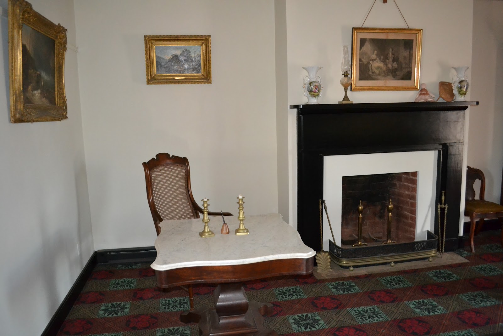
I have included pictures of the parlor room which has been restored, as closely as possible, to how it appeared on April 9th 1865. After the meeting much of the furniture in the parlor was looted by souvenir hunting Union officers. Most pieces have been recovered and are in museums around the country. All of the furniture in the room are reproductions.  The brown desk is where Sherman transcribed the terms of the surrender.


 The desk to the left is where Lee sat.


 "The silent witness". The little doll on the mantle was a toy inadvertently left by one of the Mclean's girls.  Like the other items it was taken as a souvenir however the original was returned to the NPS.  The doll on the mantel is a reproduction. The original is in the visitors center (the courthouse) in a climate controlled environment.


The road outside of the Mclean house leading to Appomattox Station. To the left is the crest of the hill where the last clash between Lee's and Grants soldiers took place. Beyond the crest stood the Union V Corp. Along this road is where the remnants of Lee's army were paraded, laid down their arms and were paroled. It was also the site where the Union Troops under General Joshua Chamberlain paid a final salute of arms to their defeated foes. A gesture reciprocated by the Confederates.

The surrender at Appomattox did not represent the surrender of all Confederate forces. However it was the signal for the other Confederate forces to follow suite. Joe Johnson's army of Tennessee, the largest surrender, took place on April 26th in North Carolina.. Other forces continued to surrender throughout May and June of 1865. The last surrender was the privateer CSS Shenandoah in Nov 1865.

After the war the town of Appomattox Court House faded away to oblivion. The village was dying before the war because the railroad. which had supplanted stage coaches, had been located a number of miles away in the new town of Appomattox Station.  After the war Virginians really didn't want anything to do with the town because of what happened there. The town was abandoned until taken over by the NPS and restored to its current state in 1947.

The Mclean's abandoned the house in 1867. For a few years it was rented by the bank.  The house was then purchased by some entrepreneurs with the idea of moving it to either Chicago for the 1893 worlds fair or to Washington as a tourist attraction. They got so far as to document and  dis-assemble the house.  Then the plan died and the pieces laid exposed to the elements. In the mid 1940's the NPS, using the plans and some of the original pieces reconstructed the house to its present state today

Monday 13 February 2012

From The Crater to Five Forks Battlefield - THE LONG WAY!!

The Petersburg National Battlefield is actually a series of sites strung across the south of the city. After leaving The Crater one departs the Eastern Front site and you travel along public roads.  What they don't tell you is the route is not very well marked. I happily went down one road and totally missed a sign to turn right. When I hit the I-95 I knew something was seriously wrong.  Lucy was useless because I didn't have any specific addresses and she wouldn't recognize the location names I gave her. She at least told me where I was so I can claim I was not completely lost, just annoyed.  I backtracked and found a little tiny road to follow (and this was the wide part).  I continued on past the Poplar Grove National Cemetery and again I missed a right hand turn  (For those who know me, especially my golf buddies, I don't get lost!!)  So it was a heck of a surprise to find myself on an even much smaller road with no where to turn around.  I finally pulled into a small church road and again was able to backtrack. Without that church I would probably still be on that #@%^ road. This was not the last of my adventures for the day.

Fort Fisher National Park Service Marker
Back on route again I arrived at another fort, Fort Fisher which was actually the largest of the forts surrounding Petersburg.  At this time I was getting pretty sick of "Forts". So I didn't take many picture.


Fort Fisher


Back in the car I found myself again on a decent road (with stoplights and everything!) for a few miles as I headed towards the Five Forks Battle Site.

Here was the situation leading up to late March 1865.  In Sept 1864 Atlanta fell to Sherman and  with other Union victories, moral in the North was high. In December Sherman had reached the sea and was moving north virtually unopposed through the Carolina's. Lincoln's political fortunes had turned around and in November he was easily re-elected President. In Petersburg, following the disaster at the Crater, Grant realize that the only way he was going to dislodge Lee's army was to completely cut off his supplies.

By mid March Grant had extended his siege line with his army of 120,000 westward until the only supply route was the South Side Railroad which run south west away from Petersburg. Lees army had dwindle to 30,00+ largely because of desertions. Sherman's rampage through Georgia, South and North Carolina had compelled many Confederate soldiers men to go home and help their families.

 Grant was now threatening the South Side Railroad at a location called Five Forks.  On April 1st  forces under General Sheridan, Grant's version of a Pit Bull, attacked Pickett's forces there and had routed them.  Despite Lee's warning Pickett had been careless. Relations between the two men had been strained following Gettysburg. Pickett never forgave Lee for ordering the infamous charge of Pickett's Divisions.  With the loss of Five Forks, Lee knew he could hold neither Petersburg nor Richmond. Sensing the weakness in Lee's lines, Grant attacked. By the evening of April 2nd Lee realized that he could no longer defend the two cities.The retreat to Appomattox Court House had begun.

Five Forks Battlefield
To the left is the battle map for Five Fork. Failing to notify his staff as to his whereabouts, General Pickett was attending a Shad lunch well behind the lines at the time and was quite unaware of the battle taking place. During the civil war an an unusual phenomena was frequently noted where observers would see a battle take place but hear no sound. One of these "acoustic blind spots" must have happened to Pickett.  Pickett need not have left for lunch that day because Sheridan certainly handed it too him. Writers often refer to Five Forks as the "Waterloo of the Confederacy".


Five Forks Intersection / Battlefield
I was hoping to get some good pictures at Five Forks but the battle field has largely over-grown with trees so pictures just were not practical. I clipped this picture on the left from the internet of  the Five Forks intersection. You are looking south-west over the intersection.  The visitor center at Five Forks, like all National Parks Service location, is excellent and deserving of a visit.


 Next Blog: How not to travel to Appomattox Court House


Sunday 12 February 2012

Petersburg - Part 2 - The Crater

Continuing from Fort Stedman , I arrived at the site of one of the most infamous Union screw-ups of the War, The Battle of the Crater.  The civil war was littered with gross mistakes of Union generalship but this one was impressive.

In July1864 the Union Armies were dug in around the northern, eastern, and southern perimeter of Richmond and Petersburg. While Richmond was the capital, Petersburg was the key. It was at the junction of major rail lines that sustained the capital. If Petersburg fell so did Richmond. The map to the left shows the lines as they appeared in the fall of 1864 but they were much the same in July.

The Overland Campaign that had preceded the siege had been a bloody affair with totals on both sides of killed, wounded and captured numbering between 70,000 and just under 100,000.  (in 2 months)

The North was war weary and facing a presidential election in the fall and Lincoln was not expected to win.

The Explosion
In July of 1864 a good plan was hatched whereby Union soldiers would tunnel under the Confederate line, explode a cache of dynamite, exploit the breach, and thereby end the siege. On July 30th 1864 at 4:44am the mine was exploded killing 278 Confederate soldiers instantly.  The crater's dimensions at the time of the explosion were 170 feet long (across the front), 120 feet wide and 30 feet deep. So far so good - right?  Wrong!! At this point the Union generals managed to snatch defeat from the jaws of victory.

The assault on The Crater
Accounts differ somewhat but the Union troops were delayed by 10 minutes and were not issued with the equipment they needed. Other accounts say that black soldiers who had been assigned as shock troops were changed at the last minute by less well briefed white soldiers.  The bottom line was that because of bad leadership they were late and instead of going around the crater they were ordered into it.  The Confederates had time to rally and turned the crater into a killing ground.  The Rebels were especially vicious with the black soldiers. Union casualties were 504 killed, 1881 wounded, and 1413 missing or captured. Confederate losses were 361 killed, 737 wounded, and 403 missing or captured.  The Confederates held the line.

The Crater from General Ambrose's vantage point
Watching the whole thing from his vantage point was General Ambrose Burnside. While later exonerated from direct blame he went on indefinite leave never to return to active duty.  The picture to the left was taken from the point where he observed the explosion.  The patch of trees dead center in the picture is the site of The Crater. It was raining heavily at the time and I was quite cold.  It seemed fitting. General Grant was quoted as saying. "It was the saddest affair I have witnessed in this war." He also stated that "Such an opportunity for carrying fortifications I have never seen and do not expect again to have. The battle is well recounted on Wikipedia and I have drawn upon it here.

The Crater - Feb 2nd 2012
I drove over to the crater itself. It's about a 2 or 3 minute walk over to the site itself from the parking lot and it was still raining quite heavily. I took this picture of the crater and quite frankly it does not look like much today. I asked one of the NPS rangers later about that and she told me that after the battle the confederates actually filled a lot of it in. I think time and erosion also had a lot to do with it.


Parts of the tunnel used to dig under the Confederate lines still exist today I found this U-Tube video which was quite interesting.


The picture above shows what the Crater looked like in 1865 after the Union had captured Petersburg
 I don't believe in ghosts, but I found it ironic that it should start raining and become cold just before arriving at the Crater. Shortly after I left, the skies cleared and it became warm. It seemed appropriate.


Saturday 11 February 2012

Petersburg - Part 1 - The Siege

The morning of the third day of my trip, Groundhog day Feb 2nd,  found me staying at a hotel in Hopewell just east of Petersburg.  Since I wanted to be traveling west towards Appomattox Court House I thought I was in the wrong part of town. It turned out I was dead wrong.

 To understand why I'll go back  to what happened in 1864. In May 1864 Grant crossed the Rapidan River near Chancellorsville in North-West Virginia.  His objective was the destruction of Lee's Army of North Virginia. Starting with the Battle of the Wilderness, Grant and Lee fought a series of battles which while inconclusive were simply battles of flanking actions and attrition. Grant ,with an army twice the size of Lee's, could afford such action.. After each battle Grant would move eastward towards Richmond until finally, in June of 1864, he surprised Lee by forming a siege corden around not just Richmond but Petersburg.  He set up his headquarters at a place called City-Point which was just a mile or so from Hopewell where I was staying.  From there, for the next 9 months, he conducted the siege of  Richmond / Petersburg until forcing Lee out in March 1865.  Just a short drive down the road from where I was staying was the Petersburg National Battlefield. The battlefield is more of a trail that sort of morphed for me into a drive to Appomattox Court House. Like all national park service battlefield the visitor center was great and from thereI followed the self guided trail.

Battery No 8
I passed several "Forts" which were lynchpins that held the Union trench system together.
Artillery Piece
 I saw very little of the trenches themselves.The area today is quite heavily forested (sort of like Chilliwack BC) today but back in 1864 the land had been stripped.


Restored Fort


One Fort has been extensive reconstructed to show what it looked like at the time of the siege
Restored Fort

Early form of barbed wire :-)


Harrison Creek


The next stop was at a little stream called Harrison Creek.  It was at this creek in March 1865 that Lee's last offensive action was stopped. The picture on the right was taken looking across the creek at the high point of the confederate advance. Hell of a defensive position.


 Past Harrison Creek was Fort Stedman which was one of the objectives of Lee's abortive March offensive.
Fort Stedman

Fort Stedman


The Battle of Averasboro - Defiance in the face of Defeat

February 1st and Day 2 of my travel north started in Savannah Georgia.  I've come to rely on my GPS, Lucy, to navigate for me. Normally it gives me navigation instructions every 20 to 30 miles.  When I got onto the I-95 it said "drive 445 miles turn right onto I-295" (I-295 being the Petersburg bypass and close to my final destination for the day.  So much for any conversations from Lucy. The I-95 from Savannah is VERY straight and I was not planning on any civil war detours (it was going to be a very long day driving) but when I stopped off at the North Carolina Tourist Bureau they mentioned a small battle site near the I-4 called the Battle of Averasboro which they said was worth a short visit.

The battle took place between March 15 and 17 1865, about a month before Lee's surrender at Appomattox Courthouse on Apr 9th and Lincoln's assassination on April 14th. After Sherman's march to the sea and the occupation of Savannah in December 1864, he was order by Grant to proceed north through the the Carolina's and into Virgina with the purpose of catching and destroying Lee's and Johnston's forces between them.  After rampaging through South Carolina (The North saw South Carolina as the root of all rebel evil being the first state to secede in 1860) with little opposition they enter North Carolina meeting little opposition until here.


At Averasboro the Confederates under General Hardee set up three defensive lines. The picture to the left shows what's left of  the first line. The car is on the confederate side of the defensive position
Battle field as seen from the first confederate defensive line


The picture to the left was taken looking south across the ground the Union troops would have to cross in the face of enemy fire.  To the left of the picture is more open ground that was also crossed by the Union.  It took all morning for the Union to breech this and the second line.

Of interest in the pictures is the "white" house in the background on the left. It served as a field hospital for the union however it was not located there at the time.  It was actually located to the right where you now see a brick bungalow.  The owner moved and rebuilt the building closer to the road. When I talked to the volunteers it was a source of contention with them. I suspect the owner of the building is going to try and turn it into a  tourist stop.


After breaching the first two lines, the union made it as far as the third line of defense where they were finally held.  On the night of the 17th the Confederates pulled out. The line is now gone and I couldn't find any markers.   The purpose of the Confederate defenses were to delay the unions long enough for General Joe Johnston to gather his forces and launch an offensive against the Sherman. Hardee's men bought him the time and on March 19th, Joe Johnson was able to launch an offensive against Sherman at a place called Bentonville. It was the last offensive ever mounted by the Confederacy.

There is a very nice small museum run mainly by volunteers. It certainly deserves a visit. They don't allow pictures to be taken inside so I have none

The battle involved 25,000 Union soliders, 8000 Confederates. the Union had 650 killed while the Confederates lost 800. The casualty numbers are unusual for the civil war in that the higher causality rate was usually with the side that was on the offensive.
 
I didn't have time to stop at Bentonville as it was further off the I-95 than I had time for. Next time

The Lost Fort - Fort McAlister

Fort McAlister
I left Orlando on the January 31st and headed north towards Savannah.  Fort Mc Alister is located just slightly south and east of Savannah Georgia. it was a "primitive" earth works fortification that guarded one of the water approaches to the city.  Ironically because of its sand earth work constructions it survived repeated shelling by Union gunboats, unlike the more modern brick / stone Fort Pulaski  just to the North. The latter fell quickly in April 1862 after shelling by rifled cannon fire. Ft Mc Alister was impervious to this type of shelling. The confederates would just fill in the craters at night and then laugh at the Gunboats who could do little.

USS Montouk
In February/March 1863 the fort was heavy bombarded by union gunboats. Casualties were relatively light. The Garrison commander was killed in one attack while the garrison cat was killed in the second. It appears that the cat was missed more.

 In late February 1863 the Blockade runner "Nashville" was caught by the gunboats just offshore from the fort and it was destroyed


Ft McAlister was seriously well armed with smooth bore and rifled cannon, morter and 230 soldiers


These batteries certainly would not make life pleasant for any union forces that got too close


To make life really nasty the Rebels would heat the balls in the "oven. Brings a whole need meaning to "What's cooking?"


Open Areas within the Fort and the ramparts
 Life for the soldiers was pretty basic. Here are the open areas within the Fort. Remember that there were no trees there at the time
Entrance to the central bombproof

Another view of the entrance to the central bombproof

For those of you who loved army drill here's the parade square.  Where's the Pipe Band?!


Living conditions were cramped. If you thought one room-mate was bad!!


Where not to be when people are shooting at you!!


The fort has some serious defenses but the spiked palisades only extended down to the high water marks. This would prove to be the Fort's fatal flaw


Would you want to climb that rampar
Ft McAlister would finally fall in December 1864 marking the end of Sherman's famous March to the Sea. Savannah was surrendered a few days later. The photo on the left shows the point where the Sherman's soldiers finally breached the fort. The union suffered 134 casualties compared to the Confederates 48.
 
That night Sherman had dinner with the fort commander but was so pissed off with him about the land-mining of the approaches that the next day he ordered the commander personally to go out and remove them. 
 
Ft McAlister was burned and abandoned by Sherman and then promptly forgotten. It was not re-discovered until the 1930's by Henry Ford who owned the land and heard stories about a "Confederate fort" on his property.  The site is now owned by the National Park Services and it is a beautiful site to visit.

Visitor Centre and parkland surrounding Fort McAlister